Tennessee Landforms -- arches and natural bridges| WGS84 |
| 36.309591 | -85.940750 |
| 36° 18.575'N | 85° 56.445'W |
| 36° 18' 34.5"N | 85° 56' 26.7"W |
| 16S 595095E 4018808N |
| Location uncertain. |
| convert to NAD27 |
Bearwaller Arch?
Waypoint: SMA001 36.309591,-85.940750
County: Smith landforms of Smith county
NABSQNO 16S-5950XX-40188XX
popup list of
nearby landforms (mileage, bearing)
MAPS
Select one of the following maps to display this waypoint (WGS84).
GPS
Remarks:
Refererence and photo: Fife brothers
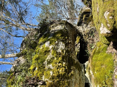
location uncertain: "arch was just off the
Bearwhaller Gap trail ... a couple of miles north of Tater Knob Overlook
Tennessee landforms
home
arches
waterfalls
rocks
peaks
balds
sinks
lakes
regions
county
GSMNP landforms (TN/NC)
BSF landforms (TN/KY)
or nearby
lookout towers
Chuck Sutherland's www.tnlandforms.com the future (2024)
 ©
Tom Dunigan
©
Tom Dunigan