Tennessee Landforms -- rock formations| WGS84 |
| 36.520500 | -84.645300 |
| 36° 31.23'N | 84° 38.718'W |
| 36° 31' 13.8"N | 84° 38' 43.1"W |
| 16S 710838E 4044261N |
| convert to NAD27 |
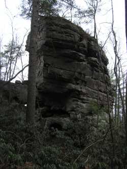
Blevins Chimney 40'
Waypoint: SCR009 36.520500,-84.645300
County: Scott landforms of Scott county
Locale: Big South Fork
popup list of
nearby landforms (mileage, bearing)
MAPS
Select one of the following maps to display this waypoint (WGS84).
GPS
Remarks:
Tennessee landforms
home
arches
waterfalls
rocks
peaks
balds
sinks
lakes
regions
county
GSMNP landforms (TN/NC)
BSF landforms (TN/KY)
or nearby
lookout towers
Chuck Sutherland's www.tnlandforms.com the future (2024)
 ©
Tom Dunigan
©
Tom Dunigan