Tennessee Landforms -- waterfalls| WGS84 |
| 36.394700 | -84.453000 |
| 36° 23.682'N | 84° 27.18'W |
| 36° 23' 40.9"N | 84° 27' 10.8"W |
| 16S 728428E 4030742N |
| convert to NAD27 |
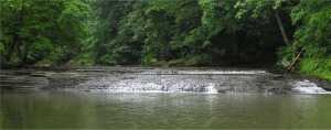
Paint Rock Creek Falls 6'
Waypoint: SCF022 36.394700,-84.453000
County: Scott landforms of Scott county
Locale: private
popup list of
nearby landforms (mileage, bearing)
MAPS
Select one of the following maps to display this waypoint (WGS84).
GPS
Remarks:
Tennessee landforms
home
arches
waterfalls
rocks
peaks
balds
sinks
lakes
regions
county
GSMNP landforms (TN/NC)
BSF landforms (TN/KY)
or nearby
lookout towers
Chuck Sutherland's www.tnlandforms.com the future (2024)
 ©
Tom Dunigan
©
Tom Dunigan