Tennessee Landforms -- arches and natural bridges| WGS84 |
| 36.584382 | -84.663498 |
| 36° 35.063'N | 84° 39.81'W |
| 36° 35' 3.8"N | 84° 39' 48.6"W |
| 16S 709036E 4051309N |
| convert to NAD27 |
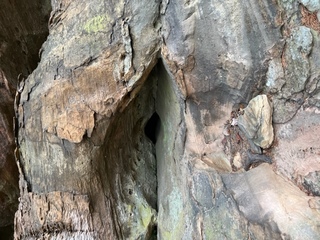
Gage's Tunnel 2x10
Waypoint: SCA078 36.584382,-84.663498
County: Scott landforms of Scott county
Locale: Big South Fork
NABSQNO 16S-709036-4051309
popup list of
nearby landforms (mileage, bearing)
MAPS
Select one of the following maps to display this waypoint (WGS84).
GPS
Remarks:
Reference and photo: Wes Hayes
Tennessee landforms
home
arches
waterfalls
rocks
peaks
balds
sinks
lakes
regions
county
GSMNP landforms (TN/NC)
BSF landforms (TN/KY)
or nearby
lookout towers
Chuck Sutherland's www.tnlandforms.com the future (2024)
 ©
Tom Dunigan
©
Tom Dunigan