Tennessee Landforms -- arches and natural bridges| WGS84 |
| 36.459771 | -84.660479 |
| 36° 27.586'N | 84° 39.629'W |
| 36° 27' 35.2"N | 84° 39' 37.7"W |
| 16S 709642E 4037490N |
| convert to NAD27 |
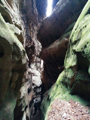
Sunset Slot 300'
Waypoint: SCA076 36.459771,-84.660479
County: Scott landforms of Scott county
Locale: Big South Fork
NABSQNO 16S-709642-4037490
popup list of
nearby landforms (mileage, bearing)
MAPS
Select one of the following maps to display this waypoint (WGS84).
GPS
Remarks:
Reference and photo: Tim Smith
Tennessee landforms
home
arches
waterfalls
rocks
peaks
balds
sinks
lakes
regions
county
GSMNP landforms (TN/NC)
BSF landforms (TN/KY)
or nearby
lookout towers
Chuck Sutherland's www.tnlandforms.com the future (2024)
 ©
Tom Dunigan
©
Tom Dunigan