Tennessee Landforms -- arches and natural bridges| WGS84 |
| 36.432900 | -84.656700 |
| 36° 25.974'N | 84° 39.402'W |
| 36° 25' 58.4"N | 84° 39' 24.1"W |
| 16S 710053E 4034517N |
| convert to NAD27 |
Adjoin Double Arch 9x2
Waypoint: SCA048 36.432900,-84.656700
County: Scott landforms of Scott county
Locale: Big South Fork
NABSQNO 16S-710053-4034517
popup list of
nearby landforms (mileage, bearing)
MAPS
Select one of the following maps to display this waypoint (WGS84).
GPS
Remarks:
Reference: Keith Garnes
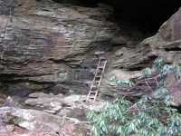
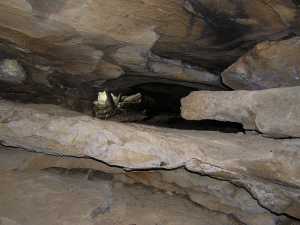
Along Honey Creek trail, climb the ladder to the rock house and
slither through the double arch to the adjoining rock house.
Tennessee landforms
home
arches
waterfalls
rocks
peaks
balds
sinks
lakes
regions
county
GSMNP landforms (TN/NC)
BSF landforms (TN/KY)
or nearby
lookout towers
Chuck Sutherland's www.tnlandforms.com the future (2024)
 ©
Tom Dunigan
©
Tom Dunigan