Tennessee Landforms -- arches and natural bridges| WGS84 |
| 36.559000 | -84.656650 |
| 36° 33.54'N | 84° 39.399'W |
| 36° 33' 32.4"N | 84° 39' 23.9"W |
| 16S 709717E 4048508N |
| convert to NAD27 |
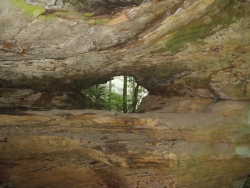
Station Camp Window 4x3
Waypoint: SCA011 36.559000,-84.656650
County: Scott landforms of Scott county
Locale: Big South Fork
NABSQNO 16S-709717-4048508
popup list of
nearby landforms (mileage, bearing)
MAPS
Select one of the following maps to display this waypoint (WGS84).
GPS
Remarks:
References: JNAD:TENN-33, John Burns
This window is located along the second bluff line near a big beech tree (off-trail).
Tennessee landforms
home
arches
waterfalls
rocks
peaks
balds
sinks
lakes
regions
county
GSMNP landforms (TN/NC)
BSF landforms (TN/KY)
or nearby
lookout towers
Chuck Sutherland's www.tnlandforms.com the future (2024)
 ©
Tom Dunigan
©
Tom Dunigan