Tennessee Landforms -- arches and natural bridges| WGS84 |
| 36.560500 | -84.559080 |
| 36° 33.63'N | 84° 33.545'W |
| 36° 33' 37.8"N | 84° 33' 32.7"W |
| 16S 718446E 4048892N |
| convert to NAD27 |
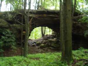
Daylight Rock 35x18
Waypoint: SCA003 36.560500,-84.559080
County: Scott landforms of Scott county
Locale: private
NABSQNO 16S-718446-4048892
popup list of
nearby landforms (mileage, bearing)
MAPS
Select one of the following maps to display this waypoint (WGS84).
GPS
Remarks:
References: JNAD:TENN-25, WAD:44.20, JNAD 20, John Burns
Tennessee landforms
home
arches
waterfalls
rocks
peaks
balds
sinks
lakes
regions
county
GSMNP landforms (TN/NC)
BSF landforms (TN/KY)
or nearby
lookout towers
Chuck Sutherland's www.tnlandforms.com the future (2024)
 ©
Tom Dunigan
©
Tom Dunigan