

| WGS84 | |
| 35.658981 | -84.933906 |
| 35° 39.539'N | 84° 56.034'W |
| 35° 39' 32.3"N | 84° 56' 2"W |
| 16S 687024E 3948092N | |
| convert to NAD27 | |
MAPS
Select one of the following maps to display this waypoint (WGS84).
GPS
Remarks:
Reference and photos: Brittani Wodicka
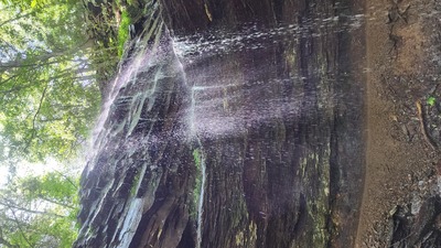
Brittanni writtes: "Cobblepot Falls has a large slanting rock cascade at the top then drops 116' off a beautiful bluff with a layer of coal and a fossil imprint. It has another small cascade that was 3.7' closeby then has another drop that could not be accessed from the bottom but measured 18' and is not pictured. The CTC built a trail along the Cumberland Trail that goes behind Cobblepot Falls This is a wet-weather waterfall. Pictures were taken in May 2023."


