Tennessee Landforms -- waterfalls| WGS84 |
| 35.691580 | -84.918330 |
| 35° 41.495'N | 84° 55.1'W |
| 35° 41' 29.7"N | 84° 55' 6"W |
| 16S 688357E 3951738N |
| convert to NAD27 |
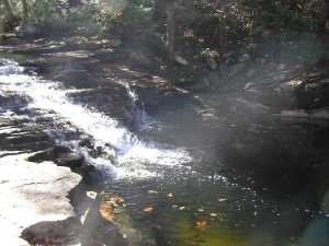
Hemlock Falls 9'
Waypoint: RHF015 35.691580,-84.918330
County: Rhea landforms of Rhea county
Locale: Cumberland Trail
popup list of
nearby landforms (mileage, bearing)
MAPS
Select one of the following maps to display this waypoint (WGS84).
GPS
Remarks:
spur off of Cumberland Trail
Tennessee landforms
home
arches
waterfalls
rocks
peaks
balds
sinks
lakes
regions
county
GSMNP landforms (TN/NC)
BSF landforms (TN/KY)
or nearby
lookout towers
Chuck Sutherland's www.tnlandforms.com the future (2024)
 ©
Tom Dunigan
©
Tom Dunigan