Tennessee Landforms -- arches and natural bridges| WGS84 |
| 35.466917 | -85.107977 |
| 35° 28.015'N | 85° 6.479'W |
| 35° 28' 0.9"N | 85° 6' 28.7"W |
| 16S 671674E 3926469N |
| convert to NAD27 |
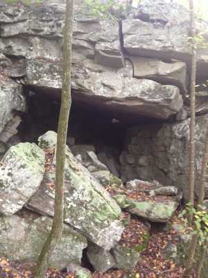
Graysville passage
Waypoint: RHA003 35.466917,-85.107977
County: Rhea landforms of Rhea county
Locale: CT
NABSQNO 16S-671674-3926469
popup list of
nearby landforms (mileage, bearing)
MAPS
Select one of the following maps to display this waypoint (WGS84).
GPS
Remarks:
A "gravity" arch (leaning rocks) that forms a passage near the Cumberland
Trail.
Tennessee landforms
home
arches
waterfalls
rocks
peaks
balds
sinks
lakes
regions
county
GSMNP landforms (TN/NC)
BSF landforms (TN/KY)
or nearby
lookout towers
Chuck Sutherland's www.tnlandforms.com the future (2024)
 ©
Tom Dunigan
©
Tom Dunigan