Tennessee Landforms -- waterfalls| WGS84 |
| 36.062303 | -85.612754 |
| 36° 3.738'N | 85° 36.765'W |
| 36° 3' 44.3"N | 85° 36' 45.9"W |
| 16S 624935E 3991749N |
| convert to NAD27 |
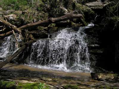
Incise Falls 8'
Waypoint: PUF010 36.062303,-85.612754
County: Putnam landforms of Putnam county
Locale: private
popup list of
nearby landforms (mileage, bearing)
MAPS
Select one of the following maps to display this waypoint (WGS84).
GPS
Remarks:
A small falls where Cane Creek is "leaking" into Phelps Branch.
rock windows and
falls nearby
Tennessee landforms
home
arches
waterfalls
rocks
peaks
balds
sinks
lakes
regions
county
GSMNP landforms (TN/NC)
BSF landforms (TN/KY)
or nearby
lookout towers
Chuck Sutherland's www.tnlandforms.com the future (2024)
 ©
Tom Dunigan
©
Tom Dunigan