Tennessee Landforms -- arches and natural bridges| WGS84 |
| 36.115196 | -85.181944 |
| 36° 6.912'N | 85° 10.917'W |
| 36° 6' 54.7"N | 85° 10' 55"W |
| 16S 663627E 3998256N |
| convert to NAD27 |
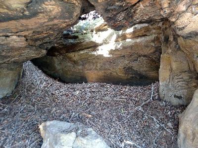
Bad Water Arch 12x5
Waypoint: PUA009 36.115196,-85.181944
County: Putnam landforms of Putnam county
NABSQNO 16S-663627-3998256
popup list of
nearby landforms (mileage, bearing)
MAPS
Select one of the following maps to display this waypoint (WGS84).
GPS
Remarks:
Reference and photo:Jon R Zetterberg
and Chuck Sutherland photo
Tennessee landforms
home
arches
waterfalls
rocks
peaks
balds
sinks
lakes
regions
county
GSMNP landforms (TN/NC)
BSF landforms (TN/KY)
or nearby
lookout towers
Chuck Sutherland's www.tnlandforms.com the future (2024)
 ©
Tom Dunigan
©
Tom Dunigan