Tennessee Landforms -- waterfalls| WGS84 |
| 35.130000 | -84.592630 |
| 35° 7.8'N | 84° 35.558'W |
| 35° 7' 48"N | 84° 35' 33.5"W |
| 16S 719350E 3890112N |
| convert to NAD27 |
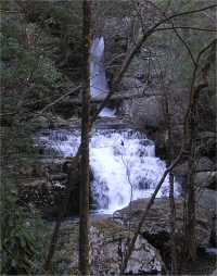
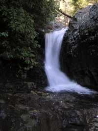
Rock Creek Falls 20'
Waypoint: POF015 35.130000,-84.592630
County: Polk landforms of Polk county
Locale: Cherokee National Forest
popup list of
nearby landforms (mileage, bearing)
MAPS
Select one of the following maps to display this waypoint (WGS84).
GPS
Remarks:
One of several falls below Benton Falls on Rock Creek.
See the Dutch Roth
1938 black & white (which he calls Thornburg Ridge)
and
thumbnails
Hike up Scenic Spur Trail
(see trail maps)
Tennessee landforms
home
arches
waterfalls
rocks
peaks
balds
sinks
lakes
regions
county
GSMNP landforms (TN/NC)
BSF landforms (TN/KY)
or nearby
lookout towers
Chuck Sutherland's www.tnlandforms.com the future (2024)
 ©
Tom Dunigan
©
Tom Dunigan