Tennessee Landforms -- waterfalls| WGS84 |
| 35.130480 | -84.593130 |
| 35° 7.829'N | 84° 35.588'W |
| 35° 7' 49.7"N | 84° 35' 35.3"W |
| 16S 719304E 3890164N |
| convert to NAD27 |
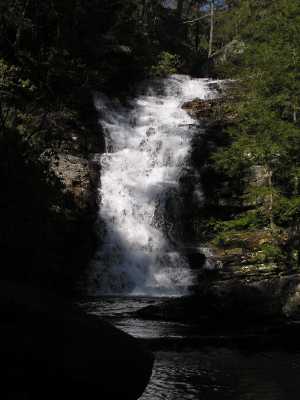
Chestnut Mountain Falls 40'
Waypoint: POF010 35.130480,-84.593130
County: Polk landforms of Polk county
Locale: Cherokee National Forest
popup list of
nearby landforms (mileage, bearing)
MAPS
Select one of the following maps to display this waypoint (WGS84).
GPS
Remarks:
One of several falls below Benton Falls on Rock Creek.
See the Dutch Roth
1938 black & white
and
thumbnails
and Morrison's photo
Hike up Scenic Spur Trail then off-trail up the creek.
(see trail maps)
Tennessee landforms
home
arches
waterfalls
rocks
peaks
balds
sinks
lakes
regions
county
GSMNP landforms (TN/NC)
BSF landforms (TN/KY)
or nearby
lookout towers
Chuck Sutherland's www.tnlandforms.com the future (2024)
 ©
Tom Dunigan
©
Tom Dunigan