Tennessee Landforms -- waterfalls| WGS84 |
| 35.079400 | -84.449400 |
| 35° 4.764'N | 84° 26.964'W |
| 35° 4' 45.8"N | 84° 26' 57.8"W |
| 16S 732548E 3884824N |
| convert to NAD27 |
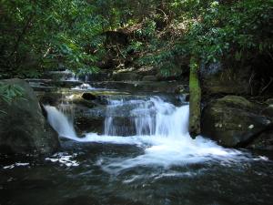
Pressley Cove Falls 5'
Waypoint: POF005 35.079400,-84.449400
County: Polk landforms of Polk county
Locale: Cherokee National Forest
popup list of
nearby landforms (mileage, bearing)
MAPS
Select one of the following maps to display this waypoint (WGS84).
GPS
Remarks:
falls on Rock Creek in
Little Frog Mountain Wilderness
CNF trail 125
Tennessee landforms
home
arches
waterfalls
rocks
peaks
balds
sinks
lakes
regions
county
GSMNP landforms (TN/NC)
BSF landforms (TN/KY)
or nearby
lookout towers
Chuck Sutherland's www.tnlandforms.com the future (2024)
 ©
Tom Dunigan
©
Tom Dunigan