Tennessee Landforms -- arches and natural bridges| WGS84 |
| 36.583048 | -84.780355 |
| 36° 34.983'N | 84° 46.821'W |
| 36° 34' 59"N | 84° 46' 49.3"W |
| 16S 698583E 4050913N |
| convert to NAD27 |
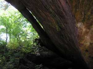
Coffee Span 18
Waypoint: PIA049 36.583048,-84.780355
County: Pickett landforms of Pickett county
Locale: forest
NABSQNO 16S-698583-4050913
popup list of
nearby landforms (mileage, bearing)
MAPS
Select one of the following maps to display this waypoint (WGS84).
GPS
Remarks:
Reference: Travis Bow
Tennessee landforms
home
arches
waterfalls
rocks
peaks
balds
sinks
lakes
regions
county
GSMNP landforms (TN/NC)
BSF landforms (TN/KY)
or nearby
lookout towers
Chuck Sutherland's www.tnlandforms.com the future (2024)
 ©
Tom Dunigan
©
Tom Dunigan