Tennessee Landforms -- arches and natural bridges| WGS84 |
| 36.570860 | -84.795710 |
| 36° 34.252'N | 84° 47.743'W |
| 36° 34' 15.1"N | 84° 47' 44.6"W |
| 16S 697240E 4049529N |
| convert to NAD27 |
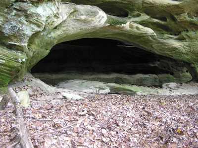
Rock Creek Arch 18x6
Waypoint: PIA046 36.570860,-84.795710
County: Pickett landforms of Pickett county
Locale: forest
NABSQNO 16S-697240-4049529
popup list of
nearby landforms (mileage, bearing)
MAPS
Select one of the following maps to display this waypoint (WGS84).
GPS
Remarks:
Reference: Travis Bo, Keith Garnes
Along bluff wall in Pickett State Forest. A small 2nd span at ankle level.
Tennessee landforms
home
arches
waterfalls
rocks
peaks
balds
sinks
lakes
regions
county
GSMNP landforms (TN/NC)
BSF landforms (TN/KY)
or nearby
lookout towers
Chuck Sutherland's www.tnlandforms.com the future (2024)
 ©
Tom Dunigan
©
Tom Dunigan