Tennessee Landforms -- arches and natural bridges| WGS84 |
| 36.597800 | -84.798300 |
| 36° 35.868'N | 84° 47.898'W |
| 36° 35' 52.1"N | 84° 47' 53.9"W |
| 16S 696940E 4052513N |
| convert to NAD27 |
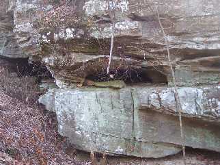
Flint Fork Arch 4x1
Waypoint: PIA038 36.597800,-84.798300
County: Pickett landforms of Pickett county
Locale: state forest
NABSQNO 16S-696940-4052513
popup list of
nearby landforms (mileage, bearing)
MAPS
Select one of the following maps to display this waypoint (WGS84).
GPS
Remarks:
Reference & photo: Keith Garnes
visible from Flint Fork Rd.
Tennessee landforms
home
arches
waterfalls
rocks
peaks
balds
sinks
lakes
regions
county
GSMNP landforms (TN/NC)
BSF landforms (TN/KY)
or nearby
lookout towers
Chuck Sutherland's www.tnlandforms.com the future (2024)
 ©
Tom Dunigan
©
Tom Dunigan