Tennessee Landforms -- arches and natural bridges| WGS84 |
| 36.527200 | -84.752000 |
| 36° 31.632'N | 84° 45.12'W |
| 36° 31' 37.9"N | 84° 45' 7.2"W |
| 16S 701265E 4044776N |
| convert to NAD27 |
Sliver Arch 10x31
Waypoint: PIA037 36.527200,-84.752000
County: Pickett landforms of Pickett county
Locale: Big South Fork
NABSQNO 16S-701265-4044776
popup list of
nearby landforms (mileage, bearing)
MAPS
Select one of the following maps to display this waypoint (WGS84).
GPS
Remarks:
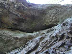 span with small separation from cliff wall
Tennessee landforms
home
arches
waterfalls
rocks
peaks
balds
sinks
lakes
regions
county
GSMNP landforms (TN/NC)
BSF landforms (TN/KY)
or nearby
lookout towers
Chuck Sutherland's www.tnlandforms.com the future (2024)
 ©
Tom Dunigan
©
Tom Dunigan