Tennessee Landforms -- arches and natural bridges| WGS84 |
| 36.527250 | -84.741360 |
| 36° 31.635'N | 84° 44.482'W |
| 36° 31' 38.1"N | 84° 44' 28.9"W |
| 16S 702218E 4044804N |
| convert to NAD27 |
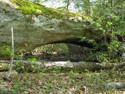
Hunchback Arch 30x5
Waypoint: PIA028 36.527250,-84.741360
County: Pickett landforms of Pickett county
Locale: Big South Fork
NABSQNO 16S-702218-4044804
popup list of
nearby landforms (mileage, bearing)
MAPS
Select one of the following maps to display this waypoint (WGS84).
GPS
Remarks:
Reference: Tom Des Jean (MTSU summer interns w/ GPS, 2003)
off-trail
Tennessee landforms
home
arches
waterfalls
rocks
peaks
balds
sinks
lakes
regions
county
GSMNP landforms (TN/NC)
BSF landforms (TN/KY)
or nearby
lookout towers
Chuck Sutherland's www.tnlandforms.com the future (2024)
 ©
Tom Dunigan
©
Tom Dunigan