Tennessee Landforms -- arches and natural bridges| WGS84 |
| 36.530760 | -84.761910 |
| 36° 31.846'N | 84° 45.715'W |
| 36° 31' 50.8"N | 84° 45' 42.9"W |
| 16S 700368E 4045150N |
| convert to NAD27 |
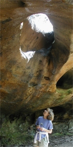
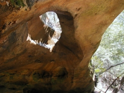
Mill Cr. Arch 20x13
Waypoint: PIA021 36.530760,-84.761910
County: Pickett landforms of Pickett county
Locale: Big South Fork
NABSQNO 16S-700368-4045150
popup list of
nearby landforms (mileage, bearing)
MAPS
Select one of the following maps to display this waypoint (WGS84).
GPS
Remarks:
Reference: Manning
This skylight can be found along the trail about 200 yds east of
Needle Arch.
Tennessee landforms
home
arches
waterfalls
rocks
peaks
balds
sinks
lakes
regions
county
GSMNP landforms (TN/NC)
BSF landforms (TN/KY)
or nearby
lookout towers
Chuck Sutherland's www.tnlandforms.com the future (2024)
 ©
Tom Dunigan
©
Tom Dunigan