Tennessee Landforms -- arches and natural bridges| WGS84 |
| 36.589500 | -84.863250 |
| 36° 35.37'N | 84° 51.795'W |
| 36° 35' 22.2"N | 84° 51' 47.7"W |
| 16S 691150E 4051461N |
| convert to NAD27 |
Smoke House Arch 17x20
Waypoint: PIA018 36.589500,-84.863250
County: Pickett landforms of Pickett county
Locale: tnc
NABSQNO 16S-691150-4051461
popup list of
nearby landforms (mileage, bearing)
MAPS
Select one of the following maps to display this waypoint (WGS84).
GPS
Remarks:
References: JNAD:TENN-43, John Burns
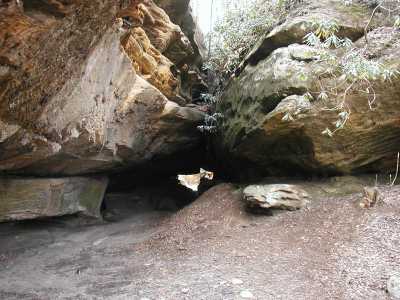
This is a 120' tunnel in a
nature conservancy area.
Nearby are Greenwood Cliff arch and tunnel and a KY chimney.
Tennessee landforms
home
arches
waterfalls
rocks
peaks
balds
sinks
lakes
regions
county
GSMNP landforms (TN/NC)
BSF landforms (TN/KY)
or nearby
lookout towers
Chuck Sutherland's www.tnlandforms.com the future (2024)
 ©
Tom Dunigan
©
Tom Dunigan