Tennessee Landforms -- arches and natural bridges| WGS84 |
| 36.545450 | -84.797509 |
| 36° 32.727'N | 84° 47.851'W |
| 36° 32' 43.6"N | 84° 47' 51.1"W |
| 16S 697144E 4046707N |
| convert to NAD27 |
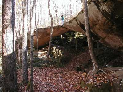
Hwy 154 Natural Bridge 86x24
Waypoint: PIA010 36.545450,-84.797509
County: Pickett landforms of Pickett county
Locale: state park
NABSQNO 16S-697144-4046707
popup list of
nearby landforms (mileage, bearing)
MAPS
Select one of the following maps to display this waypoint (WGS84).
GPS
Remarks:
References: JNAD:TENN-13, WAD:44.7
Tennessee landforms
home
arches
waterfalls
rocks
peaks
balds
sinks
lakes
regions
county
GSMNP landforms (TN/NC)
BSF landforms (TN/KY)
or nearby
lookout towers
Chuck Sutherland's www.tnlandforms.com the future (2024)
 ©
Tom Dunigan
©
Tom Dunigan