Tennessee Landforms -- arches and natural bridges| WGS84 |
| 36.541989 | -84.789068 |
| 36° 32.519'N | 84° 47.344'W |
| 36° 32' 31.1"N | 84° 47' 20.6"W |
| 16S 697908E 4046340N |
| convert to NAD27 |
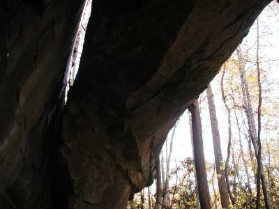
Dead Deer Arch 40x20
Waypoint: PIA004 36.541989,-84.789068
County: Pickett landforms of Pickett county
Locale: Big South Fork
NABSQNO 16S-697908-4046340
popup list of
nearby landforms (mileage, bearing)
MAPS
Select one of the following maps to display this waypoint (WGS84).
GPS
Remarks:
References: JNAD:TENN-31, WAD:44.11, JNAD 20, John Burns
Tennessee landforms
home
arches
waterfalls
rocks
peaks
balds
sinks
lakes
regions
county
GSMNP landforms (TN/NC)
BSF landforms (TN/KY)
or nearby
lookout towers
Chuck Sutherland's www.tnlandforms.com the future (2024)
 ©
Tom Dunigan
©
Tom Dunigan