Tennessee Landforms -- waterfalls| WGS84 |
| 36.487570 | -85.227950 |
| 36° 29.254'N | 85° 13.677'W |
| 36° 29' 15.2"N | 85° 13' 40.6"W |
| 16S 658729E 4039489N |
| convert to NAD27 |
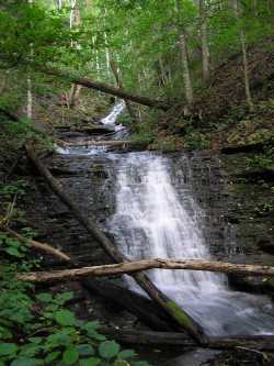
Eagle Creek Falls 40'
Waypoint: OVF015 36.487570,-85.227950
County: Overton landforms of Overton county
Locale: dalehollow
popup list of
nearby landforms (mileage, bearing)
MAPS
Select one of the following maps to display this waypoint (WGS84).
GPS
Remarks:
Tennessee landforms
home
arches
waterfalls
rocks
peaks
balds
sinks
lakes
regions
county
GSMNP landforms (TN/NC)
BSF landforms (TN/KY)
or nearby
lookout towers
Chuck Sutherland's www.tnlandforms.com the future (2024)
 ©
Tom Dunigan
©
Tom Dunigan