Tennessee Landforms -- waterfalls| WGS84 |
| 36.342200 | -85.182319 |
| 36° 20.532'N | 85° 10.939'W |
| 36° 20' 31.9"N | 85° 10' 56.3"W |
| 16S 663121E 4023438N |
| convert to NAD27 |
Falling Springs Falls 10'
Waypoint: OVF002 36.342200,-85.182319
County: Overton landforms of Overton county
Locale: private
popup list of
nearby landforms (mileage, bearing)
MAPS
Select one of the following maps to display this waypoint (WGS84).
GPS
Remarks:
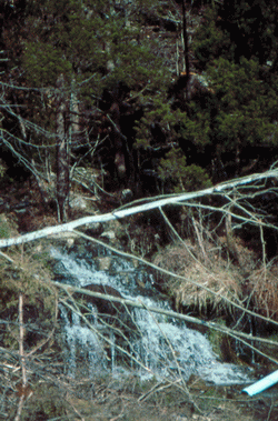 Photo by Gregory Plumb, Author of
Waterfalls of Tennessee
Photo by Gregory Plumb, Author of
Waterfalls of Tennessee
Tennessee landforms
home
arches
waterfalls
rocks
peaks
balds
sinks
lakes
regions
county
GSMNP landforms (TN/NC)
BSF landforms (TN/KY)
or nearby
lookout towers
Chuck Sutherland's www.tnlandforms.com the future (2024)
 ©
Tom Dunigan
©
Tom Dunigan