Tennessee Landforms -- waterfalls| WGS84 |
| 35.343300 | -84.197500 |
| 35° 20.598'N | 84° 11.85'W |
| 35° 20' 35.9"N | 84° 11' 51"W |
| 16S 754694E 3914720N |
| convert to NAD27 |
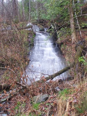
FS35 Falls 10'
Waypoint: MOF041 35.343300,-84.197500
County: Monroe landforms of Monroe county
Locale: Cherokee National Forest
popup list of
nearby landforms (mileage, bearing)
MAPS
Select one of the following maps to display this waypoint (WGS84).
GPS
Remarks:
Reference & photo: Robert Robbins
wet-weather falls
Tennessee landforms
home
arches
waterfalls
rocks
peaks
balds
sinks
lakes
regions
county
GSMNP landforms (TN/NC)
BSF landforms (TN/KY)
or nearby
lookout towers
Chuck Sutherland's www.tnlandforms.com the future (2024)
 ©
Tom Dunigan
©
Tom Dunigan