Tennessee Landforms -- waterfalls| WGS84 |
| 35.331060 | -84.179430 |
| 35° 19.864'N | 84° 10.766'W |
| 35° 19' 51.8"N | 84° 10' 46"W |
| 16S 756375E 3913408N |
| convert to NAD27 |
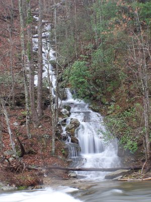
Turkey Creek Mtn Cascade 100'
Waypoint: MOF040 35.331060,-84.179430
County: Monroe landforms of Monroe county
Locale: Cherokee National Forest
popup list of
nearby landforms (mileage, bearing)
MAPS
Select one of the following maps to display this waypoint (WGS84).
GPS
Remarks:
Reference & photo: Robert Robbins
wet-weather cascade
Tennessee landforms
home
arches
waterfalls
rocks
peaks
balds
sinks
lakes
regions
county
GSMNP landforms (TN/NC)
BSF landforms (TN/KY)
or nearby
lookout towers
Chuck Sutherland's www.tnlandforms.com the future (2024)
 ©
Tom Dunigan
©
Tom Dunigan