Tennessee Landforms -- waterfalls| WGS84 |
| 35.537700 | -84.000400 |
| 35° 32.262'N | 84° 0.024'W |
| 35° 32' 15.7"N | 84° 0' 1.4"W |
| 16S 771956E 3936815N |
| convert to NAD27 |
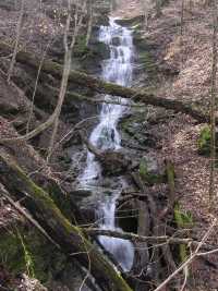
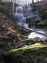
Lawson Hollow Cascade 75'
Waypoint: MOF027 35.537700,-84.000400
County: Monroe landforms of Monroe county
Locale: Chilhowee
popup list of
nearby landforms (mileage, bearing)
MAPS
Select one of the following maps to display this waypoint (WGS84).
GPS
Remarks:
series of cascades in to Chilhowee lake. wet-weather.
 40' lower cascade
 30' upper falls
Tennessee landforms
home
arches
waterfalls
rocks
peaks
balds
sinks
lakes
regions
county
GSMNP landforms (TN/NC)
BSF landforms (TN/KY)
or nearby
lookout towers
Chuck Sutherland's www.tnlandforms.com the future (2024)
 ©
Tom Dunigan
©
Tom Dunigan