Tennessee Landforms -- waterfalls| WGS84 |
| 35.427400 | -83.999400 |
| 35° 25.644'N | 83° 59.964'W |
| 35° 25' 38.6"N | 83° 59' 57.8"W |
| 17S 227689E 3924576N |
| convert to NAD27 |
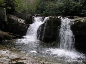
Wildcat Falls (4) 20'
Waypoint: MOF016 35.427400,-83.999400
County: Monroe landforms of Monroe county
Locale: Cherokee National Forest
popup list of
nearby landforms (mileage, bearing)
MAPS
Select one of the following maps to display this waypoint (WGS84).
GPS
Remarks:
4 falls comprise Wildcat Falls along CNF trail 42


Tennessee landforms
home
arches
waterfalls
rocks
peaks
balds
sinks
lakes
regions
county
GSMNP landforms (TN/NC)
BSF landforms (TN/KY)
or nearby
lookout towers
Chuck Sutherland's www.tnlandforms.com the future (2024)
 ©
Tom Dunigan
©
Tom Dunigan