Tennessee Landforms -- waterfalls| WGS84 |
| 35.271100 | -84.138650 |
| 35° 16.266'N | 84° 8.319'W |
| 35° 16' 16"N | 84° 8' 19.1"W |
| 16S 760275E 3906862N |
| convert to NAD27 |
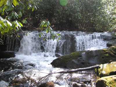
Brookshire Cr Falls 9'
Waypoint: MOF003 35.271100,-84.138650
County: Monroe landforms of Monroe county
Locale: Cherokee National Forest
popup list of
nearby landforms (mileage, bearing)
MAPS
Select one of the following maps to display this waypoint (WGS84).
GPS
Remarks:
CNF trail 180. The trail up Bald River passes over the top
of this small falls. nearby is Upper Bald River Falls. Smaller cascades
can be found upstream.
Tennessee landforms
home
arches
waterfalls
rocks
peaks
balds
sinks
lakes
regions
county
GSMNP landforms (TN/NC)
BSF landforms (TN/KY)
or nearby
lookout towers
Chuck Sutherland's www.tnlandforms.com the future (2024)
 ©
Tom Dunigan
©
Tom Dunigan