Tennessee Landforms -- waterfalls| WGS84 |
| 35.230400 | -85.554200 |
| 35° 13.824'N | 85° 33.252'W |
| 35° 13' 49.4"N | 85° 33' 15.1"W |
| 16S 631565E 3899552N |
| convert to NAD27 |
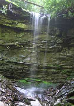
Bridge Creek Falls 35'
Waypoint: MIF017 35.230400,-85.554200
County: Marion landforms of Marion county
Locale: TNNA
popup list of
nearby landforms (mileage, bearing)
MAPS
Select one of the following maps to display this waypoint (WGS84).
GPS
Remarks:
wet-weather falls off-trail, near Chimneys
Tennessee landforms
home
arches
waterfalls
rocks
peaks
balds
sinks
lakes
regions
county
GSMNP landforms (TN/NC)
BSF landforms (TN/KY)
or nearby
lookout towers
Chuck Sutherland's www.tnlandforms.com the future (2024)
 ©
Tom Dunigan
©
Tom Dunigan