Tennessee Landforms -- waterfalls| WGS84 |
| 35.048610 | -85.407780 |
| 35° 2.917'N | 85° 24.467'W |
| 35° 2' 55"N | 85° 24' 28"W |
| 16S 645213E 3879593N |
| convert to NAD27 |
Laurel Falls 48'
Waypoint: MIF007 35.048610,-85.407780
County: Marion landforms of Marion county
popup list of
nearby landforms (mileage, bearing)
MAPS
Select one of the following maps to display this waypoint (WGS84).
GPS
Remarks:
almost dry-falls thanks to
Raccoon Mtn reservoir.
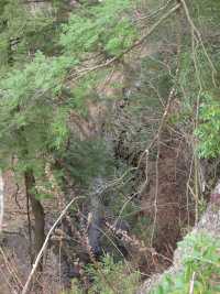
Further downstream,
John McNabb Falls
Tennessee landforms
home
arches
waterfalls
rocks
peaks
balds
sinks
lakes
regions
county
GSMNP landforms (TN/NC)
BSF landforms (TN/KY)
or nearby
lookout towers
Chuck Sutherland's www.tnlandforms.com the future (2024)
 ©
Tom Dunigan
©
Tom Dunigan