Tennessee Landforms -- waterfalls| WGS84 |
| 35.986300 | -84.545700 |
| 35° 59.178'N | 84° 32.742'W |
| 35° 59' 10.7"N | 84° 32' 44.5"W |
| 16S 721260E 3985214N |
| convert to NAD27 |
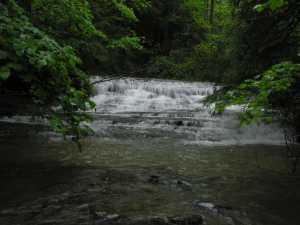
Mud Lick Falls 8'
Waypoint: MGF012 35.986300,-84.545700
County: Morgan landforms of Morgan county
popup list of
nearby landforms (mileage, bearing)
MAPS
Select one of the following maps to display this waypoint (WGS84).
GPS
Remarks:
Tennessee landforms
home
arches
waterfalls
rocks
peaks
balds
sinks
lakes
regions
county
GSMNP landforms (TN/NC)
BSF landforms (TN/KY)
or nearby
lookout towers
Chuck Sutherland's www.tnlandforms.com the future (2024)
 ©
Tom Dunigan
©
Tom Dunigan