Tennessee Landforms -- arches and natural bridges| WGS84 |
| 36.067290 | -84.652710 |
| 36° 4.037'N | 84° 39.163'W |
| 36° 4' 2.2"N | 84° 39' 9.8"W |
| 16S 711394E 3993962N |
| convert to NAD27 |
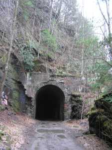
Nemo Tunnel 2174'
Waypoint: MGA011 36.067290,-84.652710
County: Morgan landforms of Morgan county
Locale: Obed Wild & Scenic River
NABSQNO 16S-711394-3993962
popup list of
nearby landforms (mileage, bearing)
MAPS
Select one of the following maps to display this waypoint (WGS84).
GPS
Remarks:
half-mile abandonded railroad tunnel. More abandonded tunnels further north
(see topos and
tunnel info).
Tennessee landforms
home
arches
waterfalls
rocks
peaks
balds
sinks
lakes
regions
county
GSMNP landforms (TN/NC)
BSF landforms (TN/KY)
or nearby
lookout towers
Chuck Sutherland's www.tnlandforms.com the future (2024)
 ©
Tom Dunigan
©
Tom Dunigan