Tennessee Landforms -- arches and natural bridges| WGS84 |
| 36.146600 | -84.499500 |
| 36° 8.796'N | 84° 29.97'W |
| 36° 8' 47.8"N | 84° 29' 58.2"W |
| 16S 724968E 4003105N |
| convert to NAD27 |
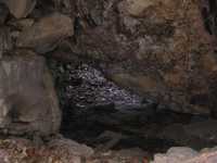
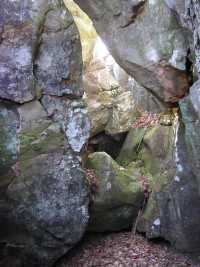
Castle Rock Arch 6x10
Waypoint: MGA007 36.146600,-84.499500
County: Morgan landforms of Morgan county
Locale: Cumberland Trail
NABSQNO 16S-724968-4003105
popup list of
nearby landforms (mileage, bearing)
MAPS
Select one of the following maps to display this waypoint (WGS84).
GPS
Remarks:
3 gravity arches northwest portion of Castle Rock, near Cumberland Trail

Tennessee landforms
home
arches
waterfalls
rocks
peaks
balds
sinks
lakes
regions
county
GSMNP landforms (TN/NC)
BSF landforms (TN/KY)
or nearby
lookout towers
Chuck Sutherland's www.tnlandforms.com the future (2024)
 ©
Tom Dunigan
©
Tom Dunigan