Tennessee Landforms -- arches and natural bridges| WGS84 |
| 36.090760 | -84.706460 |
| 36° 5.446'N | 84° 42.388'W |
| 36° 5' 26.8"N | 84° 42' 23.3"W |
| 16S 706491E 3996450N |
| convert to NAD27 |
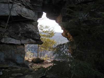
Lilly Point Arch 10x15
Waypoint: MGA005 36.090760,-84.706460
County: Morgan landforms of Morgan county
Locale: Obed Wild & Scenic River
NABSQNO 16S-706491-3996450
popup list of
nearby landforms (mileage, bearing)
MAPS
Select one of the following maps to display this waypoint (WGS84).
GPS
Remarks:
References: JNAD:TENN-54
Tennessee landforms
home
arches
waterfalls
rocks
peaks
balds
sinks
lakes
regions
county
GSMNP landforms (TN/NC)
BSF landforms (TN/KY)
or nearby
lookout towers
Chuck Sutherland's www.tnlandforms.com the future (2024)
 ©
Tom Dunigan
©
Tom Dunigan