Tennessee Landforms -- waterfalls| WGS84 |
| 36.597000 | -81.820100 |
| 36° 35.82'N | 81° 49.206'W |
| 36° 35' 49.2"N | 81° 49' 12.4"W |
| 17S 426647E 4050481N |
| convert to NAD27 |
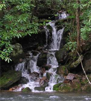
Backbone Br Cascade 10'
Waypoint: JOF003 36.597000,-81.820100
County: Johnson landforms of Johnson county
Locale: Cherokee National Forest
popup list of
nearby landforms (mileage, bearing)
MAPS
Select one of the following maps to display this waypoint (WGS84).
GPS
Remarks:
Tennessee landforms
home
arches
waterfalls
rocks
peaks
balds
sinks
lakes
regions
county
GSMNP landforms (TN/NC)
BSF landforms (TN/KY)
or nearby
lookout towers
Chuck Sutherland's www.tnlandforms.com the future (2024)
 ©
Tom Dunigan
©
Tom Dunigan