Tennessee Landforms -- waterfalls| WGS84 |
| 36.254676 | -85.569384 |
| 36° 15.281'N | 85° 34.163'W |
| 36° 15' 16.9"N | 85° 34' 9.8"W |
| 16S 628526E 4013145N |
| convert to NAD27 |
Blackburn Br Falls 45'
Waypoint: JAF015 36.254676,-85.569384
County: Jackson landforms of Jackson county
popup list of
nearby landforms (mileage, bearing)
MAPS
Select one of the following maps to display this waypoint (WGS84).
GPS
Remarks:
Reference and photo: Scott Morell
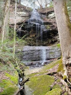 wet-weather falls
Tennessee landforms
home
arches
waterfalls
rocks
peaks
balds
sinks
lakes
regions
county
GSMNP landforms (TN/NC)
BSF landforms (TN/KY)
or nearby
lookout towers
Chuck Sutherland's www.tnlandforms.com the future (2024)
 ©
Tom Dunigan
©
Tom Dunigan