Tennessee Landforms -- waterfalls| WGS84 |
| 36.305065 | -85.752085 |
| 36° 18.304'N | 85° 45.125'W |
| 36° 18' 18.2"N | 85° 45' 7.5"W |
| 16S 612040E 4018508N |
| convert to NAD27 |
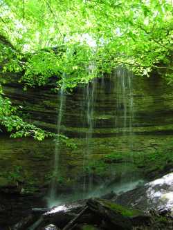
Montgomery Hollow Falls 20'
Waypoint: JAF008 36.305065,-85.752085
County: Jackson landforms of Jackson county
Locale: private
popup list of
nearby landforms (mileage, bearing)
MAPS
Select one of the following maps to display this waypoint (WGS84).
GPS
Remarks:
wet-weather falls with 50' cascade below falls, off-trail
Tennessee landforms
home
arches
waterfalls
rocks
peaks
balds
sinks
lakes
regions
county
GSMNP landforms (TN/NC)
BSF landforms (TN/KY)
or nearby
lookout towers
Chuck Sutherland's www.tnlandforms.com the future (2024)
 ©
Tom Dunigan
©
Tom Dunigan