Tennessee Landforms -- rock formations| WGS84 |
| 35.929750 | -87.733000 |
| 35° 55.785'N | 87° 43.98'W |
| 35° 55' 47.1"N | 87° 43' 58.8"W |
| 16S 433877E 3976405N |
| convert to NAD27 |
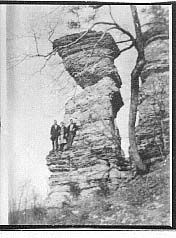
Standing Rock 40'
Waypoint: HUR001 35.929750,-87.733000
County: Humphreys landforms of Humphreys county
popup list of
nearby landforms (mileage, bearing)
MAPS
Select one of the following maps to display this waypoint (WGS84).
GPS
Remarks:
1925 photo
Tennessee landforms
home
arches
waterfalls
rocks
peaks
balds
sinks
lakes
regions
county
GSMNP landforms (TN/NC)
BSF landforms (TN/KY)
or nearby
lookout towers
Chuck Sutherland's www.tnlandforms.com the future (2024)
 ©
Tom Dunigan
©
Tom Dunigan