Tennessee Landforms -- waterfalls| WGS84 |
| 36.580650 | -82.913530 |
| 36° 34.839'N | 82° 54.812'W |
| 36° 34' 50.3"N | 82° 54' 48.7"W |
| 17S 328802E 4050058N |
| convert to NAD27 |
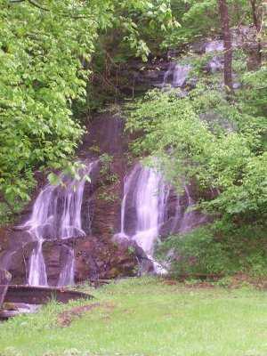
Wake Forest Falls 20'
Waypoint: HNF004 36.580650,-82.913530
County: Hancock landforms of Hancock county
Locale: private
popup list of
nearby landforms (mileage, bearing)
MAPS
Select one of the following maps to display this waypoint (WGS84).
GPS
Remarks:
Reference & photo: Robert Robbins
Tennessee landforms
home
arches
waterfalls
rocks
peaks
balds
sinks
lakes
regions
county
GSMNP landforms (TN/NC)
BSF landforms (TN/KY)
or nearby
lookout towers
Chuck Sutherland's www.tnlandforms.com the future (2024)
 ©
Tom Dunigan
©
Tom Dunigan