Tennessee Landforms -- waterfalls| WGS84 |
| 35.190590 | -85.307270 |
| 35° 11.435'N | 85° 18.436'W |
| 35° 11' 26.1"N | 85° 18' 26.2"W |
| 16S 654113E 3895491N |
| convert to NAD27 |
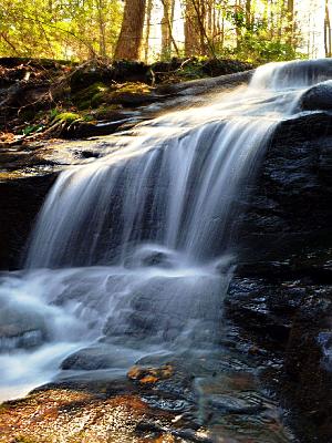
Holly Falls 10'
Waypoint: HMF026 35.190590,-85.307270
County: Hamilton landforms of Hamilton county
popup list of
nearby landforms (mileage, bearing)
MAPS
Select one of the following maps to display this waypoint (WGS84).
GPS
Remarks:
Reference: Christopher Lewis
 Daniel Jack Hutchison photo
Tennessee landforms
home
arches
waterfalls
rocks
peaks
balds
sinks
lakes
regions
county
GSMNP landforms (TN/NC)
BSF landforms (TN/KY)
or nearby
lookout towers
Chuck Sutherland's www.tnlandforms.com the future (2024)
 ©
Tom Dunigan
©
Tom Dunigan