Tennessee Landforms -- waterfalls| WGS84 |
| 35.125100 | -85.373900 |
| 35° 7.506'N | 85° 22.434'W |
| 35° 7' 30.4"N | 85° 22' 26"W |
| 16S 648165E 3888126N |
| convert to NAD27 |
Julia Falls 95'
Waypoint: HMF003 35.125100,-85.373900
County: Hamilton landforms of Hamilton county
Locale: Cumberland Trail
popup list of
nearby landforms (mileage, bearing)
MAPS
Select one of the following maps to display this waypoint (WGS84).
GPS
Remarks:
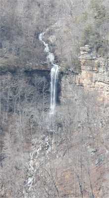
best viewed from across the canyon on the Cumberland Trail.
Nearby is Rainbow Falls and some arches.
Tennessee landforms
home
arches
waterfalls
rocks
peaks
balds
sinks
lakes
regions
county
GSMNP landforms (TN/NC)
BSF landforms (TN/KY)
or nearby
lookout towers
Chuck Sutherland's www.tnlandforms.com the future (2024)
 ©
Tom Dunigan
©
Tom Dunigan