Tennessee Landforms -- arches and natural bridges| WGS84 |
| 35.129400 | -85.363770 |
| 35° 7.764'N | 85° 21.826'W |
| 35° 7' 45.8"N | 85° 21' 49.6"W |
| 16S 649080E 3888618N |
| convert to NAD27 |
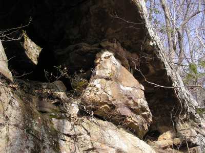
Middle Cr Arch-2 20x8
Waypoint: HMA010 35.129400,-85.363770
County: Hamilton landforms of Hamilton county
Locale: Cumberland Trail
NABSQNO 16S-649080-3888618
popup list of
nearby landforms (mileage, bearing)
MAPS
Select one of the following maps to display this waypoint (WGS84).
GPS
Remarks:
References: JNAD:TENN-46, John Burns
Tennessee landforms
home
arches
waterfalls
rocks
peaks
balds
sinks
lakes
regions
county
GSMNP landforms (TN/NC)
BSF landforms (TN/KY)
or nearby
lookout towers
Chuck Sutherland's www.tnlandforms.com the future (2024)
 ©
Tom Dunigan
©
Tom Dunigan