Tennessee Landforms -- arches and natural bridges| WGS84 |
| 35.130620 | -85.362345 |
| 35° 7.837'N | 85° 21.741'W |
| 35° 7' 50.2"N | 85° 21' 44.5"W |
| 16S 649208E 3888756N |
| convert to NAD27 |
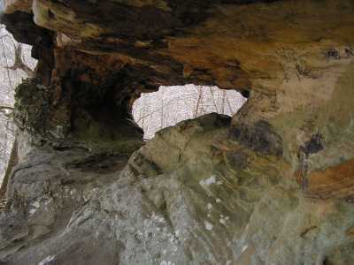
Middle Cr Arch-1 7x3
Waypoint: HMA009 35.130620,-85.362345
County: Hamilton landforms of Hamilton county
Locale: Cumberland Trail
NABSQNO 16S-649208-3888756
popup list of
nearby landforms (mileage, bearing)
MAPS
Select one of the following maps to display this waypoint (WGS84).
GPS
Remarks:
References: JNAD:TENN-51,Todd Fife
Tennessee landforms
home
arches
waterfalls
rocks
peaks
balds
sinks
lakes
regions
county
GSMNP landforms (TN/NC)
BSF landforms (TN/KY)
or nearby
lookout towers
Chuck Sutherland's www.tnlandforms.com the future (2024)
 ©
Tom Dunigan
©
Tom Dunigan