Tennessee Landforms -- waterfalls| WGS84 |
| 35.031860 | -88.132010 |
| 35° 1.912'N | 88° 7.921'W |
| 35° 1' 54.7"N | 88° 7' 55.3"W |
| 16S 396740E 3877162N |
| convert to NAD27 |
Rainbow Falls 25'
Waypoint: HDF001 35.031860,-88.132010
County: Hardin landforms of Hardin county
popup list of
nearby landforms (mileage, bearing)
MAPS
Select one of the following maps to display this waypoint (WGS84).
GPS
Remarks:
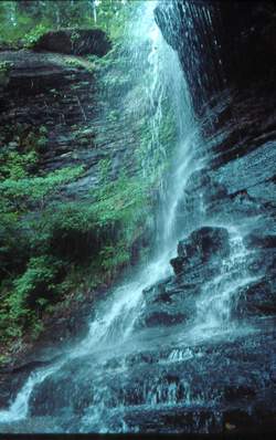 Photo by Gregory Plumb, Author of
Waterfalls of Tennessee
Photo by Gregory Plumb, Author of
Waterfalls of Tennessee
Tennessee landforms
home
arches
waterfalls
rocks
peaks
balds
sinks
lakes
regions
county
GSMNP landforms (TN/NC)
BSF landforms (TN/KY)
or nearby
lookout towers
Chuck Sutherland's www.tnlandforms.com the future (2024)
 ©
Tom Dunigan
©
Tom Dunigan