Tennessee Landforms -- waterfalls| WGS84 |
| 35.231800 | -85.749800 |
| 35° 13.908'N | 85° 44.988'W |
| 35° 13' 54.5"N | 85° 44' 59.3"W |
| 16S 613763E 3899465N |
| convert to NAD27 |
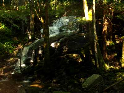
Gizzard Cascade 20'
Waypoint: GUF021 35.231800,-85.749800
County: Grundy landforms of Grundy county
Locale: trails
popup list of
nearby landforms (mileage, bearing)
MAPS
Select one of the following maps to display this waypoint (WGS84).
GPS
Remarks:
A cascade from the west spills into Fiery Gizzard Creek.
Tennessee landforms
home
arches
waterfalls
rocks
peaks
balds
sinks
lakes
regions
county
GSMNP landforms (TN/NC)
BSF landforms (TN/KY)
or nearby
lookout towers
Chuck Sutherland's www.tnlandforms.com the future (2024)
 ©
Tom Dunigan
©
Tom Dunigan