Tennessee Landforms -- waterfalls| WGS84 |
| 35.235560 | -85.877220 |
| 35° 14.134'N | 85° 52.633'W |
| 35° 14' 8"N | 85° 52' 38"W |
| 16S 602163E 3899744N |
| convert to NAD27 |
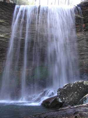
Cascade Falls 38'
Waypoint: GUF006 35.235560,-85.877220
County: Grundy landforms of Grundy county
Locale: private
popup list of
nearby landforms (mileage, bearing)
MAPS
Select one of the following maps to display this waypoint (WGS84).
GPS
Remarks:
Tennessee landforms
home
arches
waterfalls
rocks
peaks
balds
sinks
lakes
regions
county
GSMNP landforms (TN/NC)
BSF landforms (TN/KY)
or nearby
lookout towers
Chuck Sutherland's www.tnlandforms.com the future (2024)
 ©
Tom Dunigan
©
Tom Dunigan